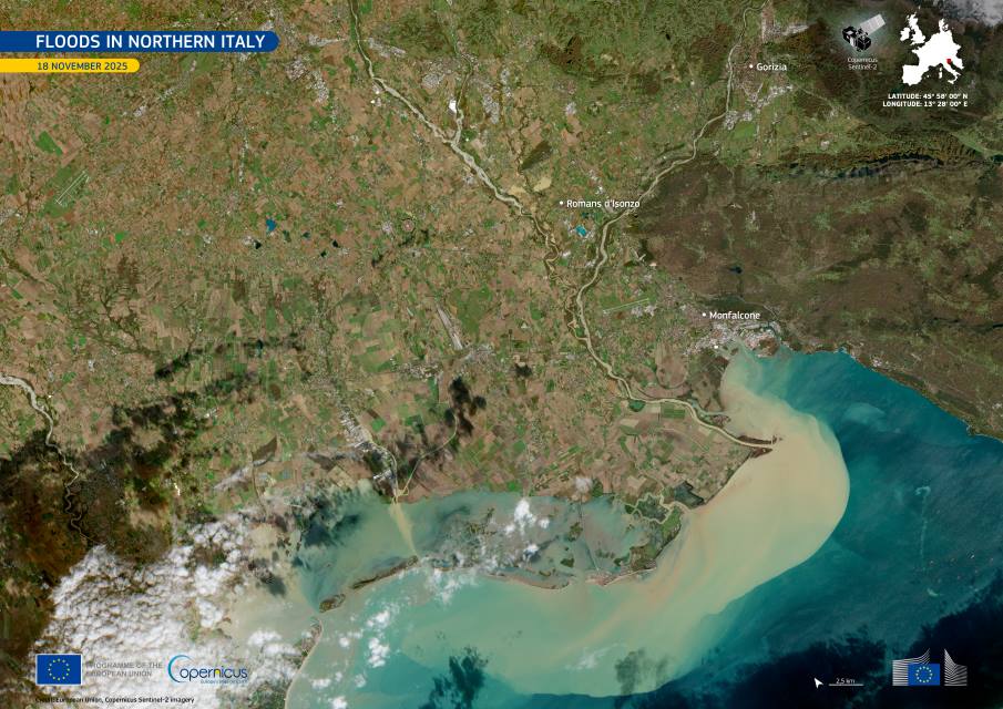
Floods in northern Italy reshaped parts of the Friuli Venezia Giulia region on 18 November 2025, when intense rainfall overwhelmed rivers around Gorizia and Romans d’Isonzo. The scale of runoff moving through the landscape became visible along the coast, where the Gulf of Trieste turned noticeably lighter in colour as inland waters carried large volumes of sediment toward the sea. The image of the day highlights how these floodwaters interacted with the terrain, pushing suspended material outward from the mouth of the Isonzo River.
Homes and farmland near the river corridors faced widespread inundation after water levels rose sharply. Emergency crews worked across several towns, responding to blocked roads, flooded residential areas, and a landslide in Brazzano di Cormons that damaged buildings. Local authorities reported fatalities linked to the event, as well as evacuations in Romans d’Isonzo where residents were moved from areas surrounded by fast-moving water.

In the middle of the scene, a Copernicus Sentinel-2 image acquired on 18 November shows the light brown plumes stretching along the shoreline, marking the path of the sediment-rich flow entering the Gulf of Trieste. The contrast between coastal waters and the open sea illustrates how quickly material from upstream collected near the coast after the rivers overtopped their banks.
Emergency teams depended on updated maps to monitor blocked transport routes and to coordinate evacuations in areas where water remained high. Open data from the Sentinel-2 satellites supported those efforts by providing a clear view of the flooded lowlands and the shifting patterns of sediment transport. The image also adds context for post-disaster assessments, documenting how the flood pulse travelled through the region and into the Adriatic Sea.
Featured image credit: European Union, Copernicus Sentinel-2 imagery


