Flooding in northern Sumatra follows the arrival of Cyclone Senyar, which formed unexpectedly in the Strait of Malacca during the night of 25–26 November 2025. The system developed in a region where tropical cyclones had not been recorded for decades and moved quickly toward Indonesia, making landfall the next day. Its impact triggered widespread flooding and landslides across Sumatra, with more than 700 casualties reported by international media outlets.
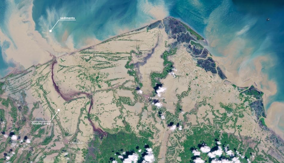
Captured on 29 November 2025, the Copernicus Sentinel-2 image shows large areas of Aceh province inundated after the storm. Towns including Lhoksukon and Panton Labu appear surrounded by floodwater, and pale plumes extending from river mouths into the sea mark the outflow of sediment mobilised by intense upstream rainfall. The pattern of flooding visible across farmland, settlements, and transport corridors reflects the concentration of rainfall and the proximity of communities to low-lying river systems.

Senyar’s formation in the Strait of Malacca illustrates how shifts in regional atmospheric and oceanic conditions can lead to cyclones forming in locations with little historical precedent. Its rapid development close to shore left limited time for preparation, contributing to the extent of the damage recorded across northern Sumatra. Reports from national and international agencies describe emergency operations taking place in areas cut off by high water and landslides.
Open data from the Copernicus Sentinel programme plays a central role in tracking flood progression and guiding response efforts. Regular satellite coverage provides authorities with consistent information on inundated areas and access routes, supporting decisions on relief distribution and early recovery planning.
Featured image credit: European Union, Copernicus Sentinel-2 imagery


