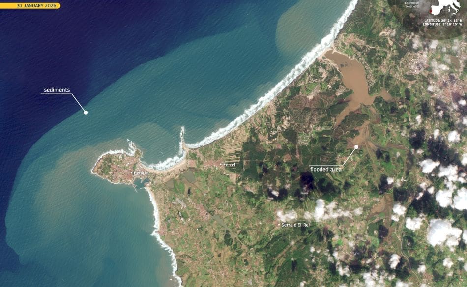
A period of severe winter weather disrupted large parts of Portugal in late January 2026, as Storm Kristin brought heavy rainfall, strong winds, and dangerous sea conditions to the country. The storm affected several central regions, contributing to five fatalities and triggering flooding across river basins and low-lying areas. Coastal communities were also exposed to intense Atlantic swell, compounding the impacts of prolonged rainfall inland.
As conditions deteriorated, the Copernicus Emergency Management Service (EMSR861) was activated on 28 January to support emergency response and situational awareness. Rapid Mapping products were requested to assess flood extent and storm-related damage to buildings, infrastructure, transport networks, and utilities across central Portugal. The activation also extended to parts of southern Spain, where river overflow was forecast along sections of the Guadalquivir basin in Andalusia.

Along Portugal’s western coast, the effects of the storm were clearly visible near Peniche at the end of January. Copernicus Sentinel-2 data acquired on 31 January 2026 show long, continuous bands of breaking waves lining the shoreline, reflecting sustained heavy swell generated by the storm. Light brown plumes of suspended sediment spread through nearshore waters, indicating material stirred up from the seabed by powerful wave action. Inland, near the town of Ferrel, darker brown areas reveal flooded fields and wetlands, where water inundated low-lying land during and after the storm.
While recovery efforts were still under way, Portugal faced another major weather system just days later. On 3 February, Storm Leonardo brought renewed periods of heavy and persistent rainfall, strong winds, and significant maritime agitation. Several river basins experienced substantial hydrological stress, with flash flood notifications issued for parts of the country and multiple areas identified as vulnerable to landslides.
A second Copernicus Emergency Management Service Rapid Mapping activation (EMSR864) followed on 3 February, focusing on flood extent and damage assessment linked to the new storm. The back-to-back activations illustrate how closely spaced winter storms can amplify impacts, particularly in catchments and coastal zones already saturated by earlier rainfall.
Featured image credit: European Union, Copernicus Sentinel-2 imagery


