Floods along the Garonne River after Storm Nils show the scale of a month of flood alerts in France, as satellite data captures inundated land around Bordeaux in mid-February 2026.
Since the beginning of the year, a series of Atlantic low-pressure systems has brought persistent and heavy rainfall across much of the country. For 30 consecutive days, several areas remained under orange or red alert. At one point, 81 departments were simultaneously on alert for 154 rivers – the highest number ever recorded at the same time.
The latest system, Storm Nils, struck south-western France and pushed the Garonne beyond its banks. Roads and residential districts were submerged, particularly in the Gironde department. In Langon and La Réole, significant overflows were reported, while other towns such as Cadillac faced rising waters. According to regional authorities, tens of thousands of households were left without electricity and many roads were closed as the river continued to rise toward its expected peak.

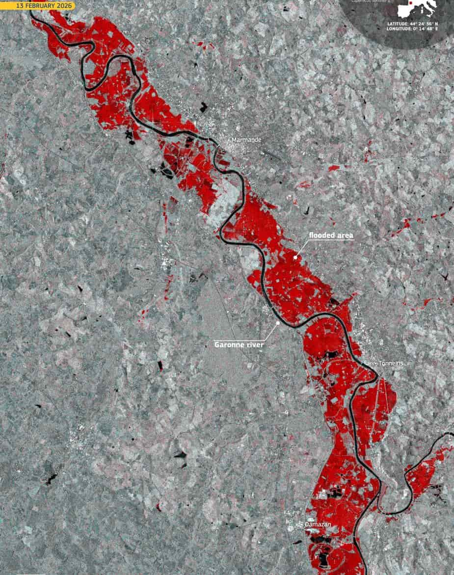
The flooded areas are visible in red tones in this image acquired by one of the Copernicus Sentinel-1 satellites on 13 February 2026. Using radar technology, Sentinel-1 can detect water surfaces through cloud cover and rainfall, allowing emergency teams to map the extent of inundation even during severe weather.
In response to the deteriorating situation, the Copernicus Emergency Management Service (CEMS) activated its rapid mapping component on 11 February 2026 under activation EMSR866. The service was tasked with providing flood extent and damage assessment maps for the Bordeaux region, as well as the Charente and Dronne river basins. Based on satellite analysis, around 29,730 people were potentially affected across seven areas of interest. Approximately 1,180 hectares of built-up areas, 1,690 kilometres of roads and 89 kilometres of railway were estimated to have been impacted.
Flood, heavy rain, avalanche and strong wind warnings were issued across large parts of France during the week, with dozens of departments under various levels of vigilance. The situation in Nouvelle-Aquitaine remained among the most severe, with red flood alerts maintained as river levels continued to fluctuate.
The image provides a detailed view of how prolonged rainfall and successive storms can translate into widespread riverine flooding. As water spreads across floodplains and infrastructure, satellite monitoring plays a central role in supporting civil protection authorities and assessing the evolving impact on communities.
Featured image credit: European Union, Copernicus Sentinel-1 imagery


