Stockholm lies where Lake Mälaren meets the Baltic Sea, a setting that has shaped the Swedish capital for centuries. The city spreads across 14 islands connected by 57 bridges, forming an urban landscape where waterways influence daily life as much as streets do. Founded in 1252 by the Swedish statesman Birger Jarl, Stockholm quickly developed into Sweden’s main trading centre, controlling the narrow maritime passage between inland regions and the Baltic. Today the metropolitan area counts more than 2,400,000 residents, making it the largest urban region in Scandinavia.
Geography continues to shape the character of the city. Roughly one-third of Stockholm’s municipal area is water and another third is green space. Just east of the capital begins the Stockholm archipelago, a coastal landscape of around 30,000 islands and skerries extending into the Baltic Sea. Ferries link many of these islands throughout the year, while during summer they become destinations for boating and outdoor activities.
A capital shaped by history and culture
Centuries of history remain visible in the streets of Gamla stan, Stockholm’s Old Town, where narrow medieval alleyways run between colourful buildings and stone churches. One of the smallest streets, Mårten Trotzigs gränd, measures about 90 centimetres at its narrowest point, making it the tightest passage in the district.
Museums are another defining feature of the Swedish capital. Stockholm hosts more than 80 museums, including the Vasa Museum, which houses a preserved 17th-century warship recovered from Stockholm harbour, and Skansen, the world’s oldest open-air museum. Beneath the city, the metro network also contains an unusual cultural element: many of its roughly 100 stations feature murals, sculptures and installations, turning parts of the underground system into what is often described as the world’s longest art gallery.
The arrival of spring in Stockholm
March marks a gradual turning point in Stockholm’s long Nordic winter. In Sweden, the arrival of spring is not defined by the calendar but by meteorological criteria established by the Swedish Meteorological and Hydrological Institute (SMHI). Spring officially begins when the daily mean temperature remains above 0 °C for seven consecutive days. Around Stockholm this transition often occurs during March, although the exact timing varies each year depending on winter conditions.
The seasonal shift also coincides with a rapid increase in daylight at this northern latitude near 59° N. Between early February and the end of March, Stockholm gains roughly six additional hours of daylight as the Sun climbs higher above the horizon. Together with gradually rising air temperatures, the stronger solar radiation contributes to the seasonal weakening and eventual melting of ice in surrounding lakes and coastal waters.

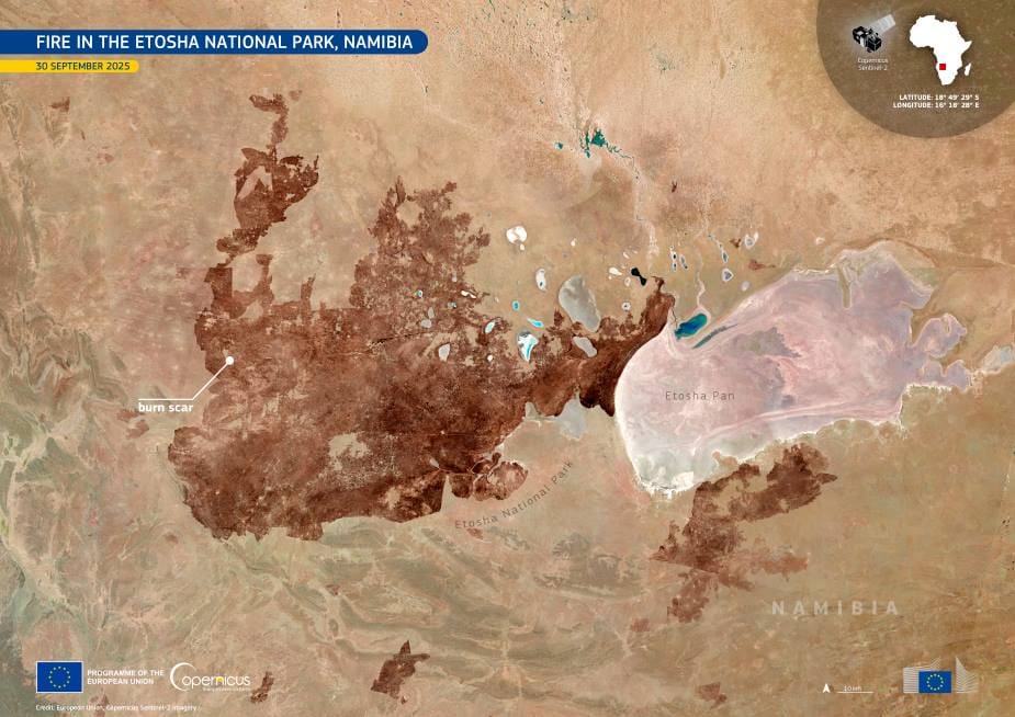
This seasonal transition can be observed from orbit. In a Copernicus Sentinel-2 image acquired on 8 March 2026, the waters around Stockholm display a mosaic of colours linked to the retreat of winter ice. Dark blue areas indicate open water where the ice has already melted, while lighter bluish tones reveal zones still partially covered by thin ice. Across the surrounding landscape, bright green patches mark the forests that cover large parts of the region around the Swedish capital.
The forests visible around Stockholm form part of the boreal landscape that extends across much of Sweden. Pine, spruce and birch dominate these woodlands, which stretch from the city’s outskirts into protected areas and nature reserves. Even within the capital, extensive green zones remain accessible to residents, including the island park of Royal Djurgården, covering more than 270 hectares, as well as forested trails reaching into neighbouring counties. These areas support wildlife and help regulate the region’s urban climate.
Satellites from the European Union’s Copernicus Earth Observation Programme provide continuous data on environmental conditions across the planet. The Sentinel-2 mission, designed to monitor land and coastal areas at high resolution, allows scientists and authorities to observe seasonal changes such as vegetation growth, snow cover and the formation or retreat of ice. These data support applications ranging from urban planning and water management to agriculture, forestry and the monitoring of environmental change in regions such as the Stockholm archipelago.
Featured image credit: European Union, Copernicus Sentinel-2 imagery