A rapidly intensifying tropical system crossing the Coral Sea in March 2026 brought rare and potentially severe conditions to northern Australia, as Tropical Cyclone Narelle strengthened significantly on its approach to Queensland’s Cape York Peninsula.
Tropical Cyclone Narelle formed on 16 March 2026 in the Coral Sea, off the north-east coast of Queensland. Over the following days, it intensified quickly while moving westward, reaching Category 5 – the highest tropical cyclone classification – on 19 March before weakening slightly ahead of landfall, while remaining capable of producing destructive winds and intense rainfall. The system marked the first cyclone of this intensity to affect the Cape York Peninsula since Cyclone Mahina in 1899, which caused more than 300 deaths.

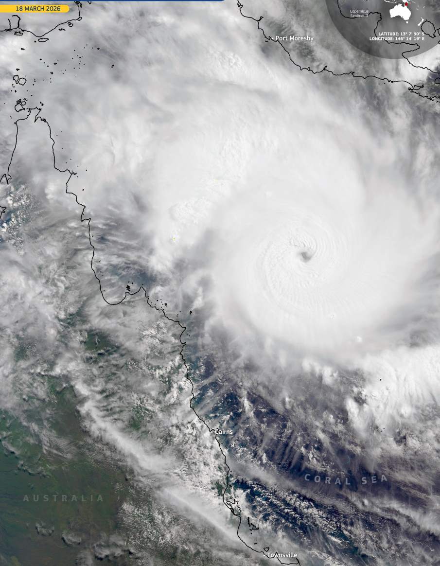
This image, acquired by one of the Copernicus Sentinel-3 satellites on 18 March 2026 at 12:11 UTC, shows Narelle over the Coral Sea as it moved toward Australia. The cyclone’s structure is clearly defined, with a dense central cloud mass and tightly curved spiral bands extending across the ocean. The compact organisation of the system indicates a phase of rapid intensification over warm waters, north-east of Queensland and east of the Torres Strait.
As Narelle approached the coast near communities such as Lockhart River and Coen in Far North Queensland, authorities monitored its development due to the risk of destructive winds, heavy rainfall, flooding, and coastal impacts. Forecasts indicated wind gusts could exceed 250 km/h near the core, with rainfall totals of several hundred millimetres possible across parts of Cape York Peninsula. The region’s remote geography and limited infrastructure increase its exposure to severe weather events of this scale.
After crossing Cape York around 20 March as a high-end Category 4 system, the cyclone was expected to track westward into the Gulf of Carpentaria, raising the possibility of multiple landfalls across northern Australia, including the Northern Territory and potentially Western Australia over the following days.
Events such as Narelle are occurring in a changing climate system, where warmer ocean temperatures provide more energy for tropical cyclones. While no single storm can be directly attributed to climate change, rising sea surface temperatures around Australia are linked to an increased likelihood of more intense cyclones, with stronger winds and heavier rainfall.
Copernicus Sentinel data plays a central role in observing tropical storms and other extreme weather events worldwide, supporting environmental assessment, improving understanding of storm dynamics, and helping authorities prepare for and mitigate their impacts.
Featured image credit: European Union, Copernicus Sentinel-3 imagery