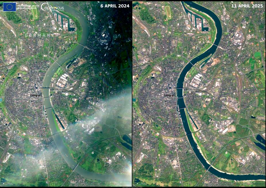
Germany is experiencing an unusually dry start to the year, with March 2025 becoming the driest March ever recorded in the country. The effects are visibly stark in western Germany, where the Rhine River – one of Europe’s most important waterways – has shrunk dramatically. A Copernicus Sentinel-2 satellite image from 11 April 2025 reveals how low water levels have exposed sandbanks near Cologne, compared with the same location one year earlier.
On 12 April 2025, water levels on the Rhine in Cologne measured just 1.54 metres – about half of what is typically expected for this time of year. This drop is part of a broader pattern: across several regions, the moisture content in the upper layers of soil has been up to 20% below the long-term minimum, according to Germany’s weather service. The prolonged dry conditions are already raising concerns for agriculture, shipping, and ecosystems.

Satellite imagery plays a critical role in capturing the scale of such environmental changes. The images, taken a year apart – on 6 April 2024 and 11 April 2025 – highlight a marked reduction in river volume. Exposed sandbanks now line areas that were fully submerged last spring. These visual records help scientists, policymakers, and local authorities monitor the extent and impacts of droughts with precision.
The Copernicus Sentinel-2 mission, operated by the European Union’s Copernicus Earth observation programme, offers open-access satellite data that supports water management, agricultural planning, and emergency response. During droughts, it becomes an indispensable tool for tracking declining water bodies and assessing the resilience of landscapes to prolonged dry spells.
As Germany contends with what meteorologists have called a “worrying” dry spell, questions about long-term water security and climate resilience are coming to the forefront. While rainfall may eventually return, the satellite images from April offer a sobering reminder of how rapidly river systems can change in a warming and drying climate.
Featured image credit: European Union, Copernicus Sentinel-2 imagery


