A destructive weather system swept across New Zealand in late April 2025, bringing intense rainfall and damaging winds that left a trail of disruption in both islands. The storm, driven by a deepening low-pressure system over the Tasman Sea, led to widespread flooding and wind damage, especially in central and southern regions. The country’s national weather service, MetService, issued a rare red warning – the highest level possible – and Christchurch declared a state of emergency in response to the escalating crisis.
In less than 12 hours, some parts of New Zealand recorded more than 100 mm of rain. Rivers across the Canterbury region broke their banks, roads were closed due to rising waters and debris, and residents were advised to stay indoors or evacuate in vulnerable areas. In Wellington, gusts surpassed 144 km/h, causing damage to infrastructure and trees, with reports of power outages and canceled ferry and flight services.

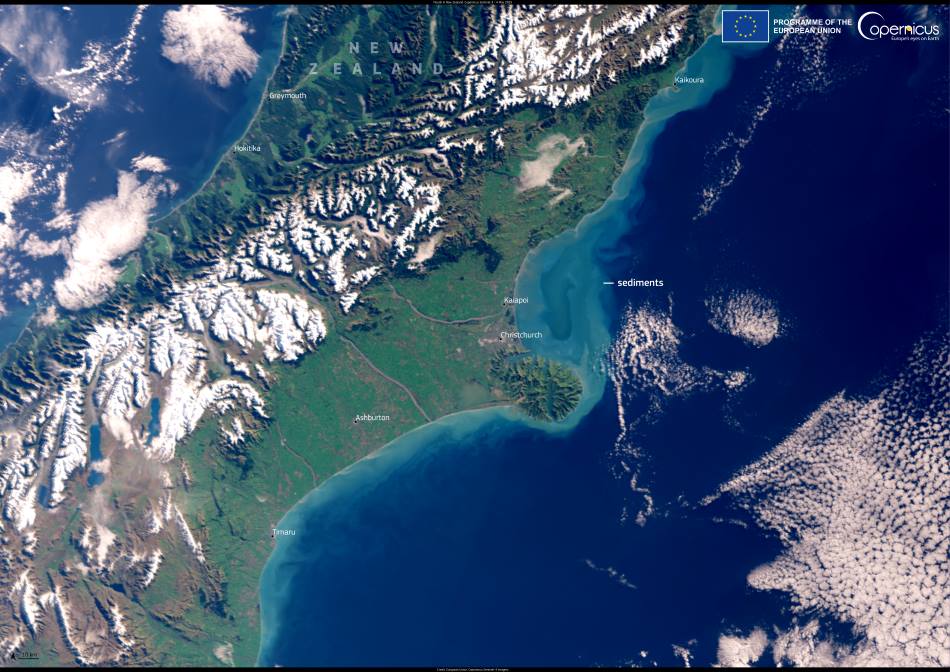
This Copernicus Sentinel-3 image, captured on 4 May 2025, shows the aftermath of the storm as it played out along the coastline near Christchurch. Large amounts of sediment, washed into rivers by the torrential rains, were flushed into Pegasus Bay. These sediment plumes are clearly visible in the image as lighter, muddy swirls in the otherwise darker waters of the bay. Stormwater runoff like this can carry not only soil but also pollutants and organic matter from inland areas, affecting coastal ecosystems and water quality.
The Copernicus Sentinel satellites are equipped to capture and monitor environmental changes in near real-time. Their data is crucial for emergency response and damage assessment following major weather events, allowing authorities to map flood-affected zones and track how landscapes are altered by extreme climate conditions. In New Zealand, where such storms are projected to increase in frequency and intensity under climate change scenarios, satellite imagery provides an indispensable tool for early warning, planning, and recovery.
Featured image credit: European Union, Copernicus Sentinel-3 imagery


