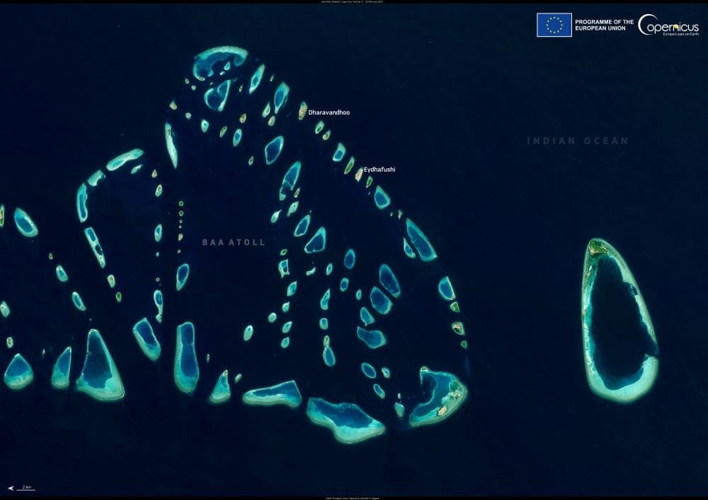
Fringed with white-sand beaches and teeming with marine life, Baa Atoll in the Maldives stands out not only as a stunning tropical paradise but also as a vital ecological stronghold. Captured in a detailed Copernicus Sentinel-2 satellite image on 19 February 2025, the atoll’s intricate coral reefs and scattered islands reveal the vibrant interplay between land and sea that defines this UNESCO Biosphere Reserve.
Located in the western part of the Maldives, Baa Atoll consists of 75 islands, 13 of which are inhabited. Despite its modest size, it holds extraordinary biodiversity. The atoll is home to over 250 species of coral and more than 1,200 species of fish, including manta rays (Mobula alfredi), whale sharks (Rhincodon typus), and green and hawksbill sea turtles. These waters serve as a critical feeding and breeding ground, particularly for manta rays, which gather in large numbers at Hanifaru Bay — a marine protected area known globally for its seasonal plankton blooms that attract these graceful filter-feeders.
In recognition of its ecological richness and ongoing conservation efforts, Baa Atoll was designated a UNESCO Biosphere Reserve in 2011, the first and only such reserve in the Maldives. The designation reflects a commitment to harmonizing conservation with sustainable development. According to UNESCO, the reserve aims to “combine the conservation of biodiversity with the sustainable use of natural resources,” balancing ecological preservation with the needs of the local population and tourism-based economy.

One of the core strategies involves close collaboration between local island councils, the government of the Maldives, and the tourism sector. Several high-end resorts in the atoll have integrated marine conservation into their business models, employing marine biologists, funding coral restoration projects, and implementing strict guidelines on waste management, reef protection, and sustainable water use. Local communities have also developed eco-tourism initiatives, such as community-run guesthouses and guided snorkeling tours, which generate income while promoting environmental stewardship.
Visible from orbit, the atoll’s reef systems are a central focus of remote sensing programs aimed at tracking the health of coral ecosystems in the face of mounting climate threats. The Copernicus Sentinel-2 satellite, part of the European Union’s Earth observation program, provides high-resolution optical imagery that enables scientists to assess reef bleaching, sedimentation, and algal overgrowth. This monitoring is especially vital given that coral reefs in the Maldives have suffered mass bleaching events in recent decades, linked to prolonged marine heatwaves driven by rising global temperatures.
Complementing this, the Copernicus Marine Service offers data on sea surface temperature (SST), ocean currents, salinity, and biogeochemical parameters. SST in particular is a key metric for assessing the vulnerability of coral reefs to thermal stress. Even small increases in temperature, typically just 1–2°C above the seasonal norm, can disrupt the symbiotic relationship between corals and the algae that live within them, leading to bleaching. The availability of open-access data allows scientists, conservationists, and policymakers to make informed decisions and respond quickly to early signs of stress.
Beyond its reefs, Baa Atoll’s role in broader climate resilience is also significant. Coral reefs serve as natural breakwaters, buffering coastal communities from the impact of storm surges and erosion. With the Maldives standing just 1–2 meters above sea level on average, healthy reefs provide a critical line of defense against the rising tides of climate change.
As global concern grows over the future of coral reef systems, Baa Atoll offers a model of how remote sensing, local stewardship, and international collaboration can come together to protect one of the planet’s most vibrant and vulnerable ecosystems. The Sentinel-2 image is more than a visual snapshot — it’s a reminder of the intricate natural systems at play and the responsibility to sustain them.
Featured image credit: European Union, Copernicus Sentinel-2 imagery


