Lake Tisza in eastern Hungary is the country’s second-largest lake, covering about 127 square kilometres. Formed along the River Tisza, which flows directly through it, the lake is part of Hortobágy National Park – an expanse of grassland known as the Puszta that has been recognised as a UNESCO World Heritage site since 1999. The combination of open water, shallow zones, dead-end channels, and islands gives the area a distinctive mosaic landscape that supports rich biodiversity.
The wetlands around Lake Tisza are a vital habitat for numerous bird species, making it an important stopover along migratory routes. Some areas, such as the Lake Tisza Bird Reserve, can only be visited through guided tours to protect sensitive wildlife. Conservation efforts here are balanced with recreation: visitors can hike, cycle, or explore the waterways by boat, while designated areas also allow for swimming and even motorised water sports – rare among Europe’s natural lakes.

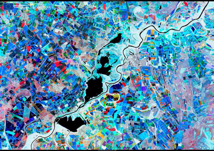
This Copernicus Sentinel-2 image blends data from 12 August, 6 September, and 16 October 2023 to illustrate seasonal activity in the region. Lake Tisza appears in black, with permanent vegetation in white. Agricultural fields are coloured according to when they were active: red for October, green for September, and blue for August. Yellow and orange plots mark land cultivated between September and October.
The image captures how farming patterns shift around the lake, contrasting with the stability of the wetlands and protected habitats. Satellite observations such as these help monitor the interaction between agriculture, water systems, and conservation areas. For Lake Tisza, they contribute to strategies that aim to safeguard its ecological value while supporting tourism and local livelihoods.
Featured image credit: European Union, Copernicus Sentinel-2 imagery


