Ballypatrick Forest lies high on the Antrim Plateau in County Antrim, Northern Ireland, forming part of the Antrim Coast and Glens Area of Outstanding Natural Beauty. Established after the Second World War, its earliest trees were planted in 1948 and still stand near the entrance today. While the forest was initially developed as a commercial plantation dominated by Sitka spruce, it has since become a more varied and ecologically valuable landscape. Oak, rowan, birch, ash, and hazel intermingle with the conifers, and areas of open heath and blanket bogs remain across the plateau.
The forest is both a recreational retreat and an important wildlife habitat. Its network of roads and tracks offers routes for walkers, cyclists, and birdwatchers, though paths are often unmarked, giving visitors a sense of exploring wilder ground. Scenic spots include Glenmakeeran and Corratavey Burn, with views stretching toward Knocklayd Mountain. The Vanishing Lake, or Loughareema, lies nearby, drawing visitors with its unusual tendency to appear and disappear depending on underground water levels. Picnic areas and parking facilities make the forest accessible, though much of its appeal lies in its unstructured, open character.
Ballypatrick Forest has become increasingly significant for conservation in Northern Ireland. It supports a range of mammals including deer, badgers, and the elusive pine marten, a species once almost lost from the region. Protected under the Wildlife (NI) Order 1985, the pine marten has been steadily recovering. Its resurgence has had a notable ecological impact, as pine martens help suppress populations of invasive grey squirrels, allowing native red squirrels to return.
Surveys and monitoring by groups such as the Glens Red Squirrel Group have recorded encouraging numbers of red squirrels thriving once more within the forest. Studies by the People’s Trust for Endangered Species have also shown how pine martens adapt their diet seasonally, taking fruit, insects, birds, and small mammals, enabling them to live successfully in both native woods and commercial plantations.

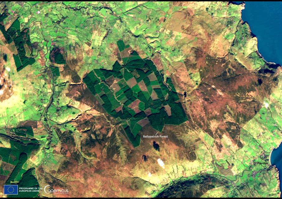
This Copernicus Sentinel-2 image, acquired on 28 February 2025, shows Ballypatrick Forest from above, with its contrasting blocks of conifer plantation, open heathland, and bog. Satellite data from the Copernicus programme are widely used to monitor forest health, assess biodiversity, and track the impacts of climate change on vulnerable habitats. In places like Ballypatrick, where ecological restoration and commercial forestry overlap, this imagery provides valuable insight into long-term landscape change.
The forest’s rivers add to its ecological and hydrological importance. The Glenmakeeran River has its source within Ballypatrick, while the Carey River rises in its eastern reaches. These upland streams feed into a wider network of catchments that sustain surrounding farmland and coastal habitats. The forest also contributes to carbon storage through its plantations and peat soils, making its management significant for both biodiversity and climate policy.
Today, Ballypatrick Forest reflects the balance between past economic priorities and present conservation goals. Once planted primarily for timber, it is now valued as much for its wildlife, its role in supporting native species, and its opportunities for recreation. Efforts to restore broadleaf woodland, protect sensitive bog habitats, and safeguard species like the pine marten show how landscapes shaped by human intervention can evolve toward greater ecological resilience. Seen from space, the forest appears as a patchwork of habitats, and on the ground, it remains a living example of how upland forests in Northern Ireland are being reimagined for the future.
Featured image credit: European Union, Copernicus Sentinel-2 imagery


