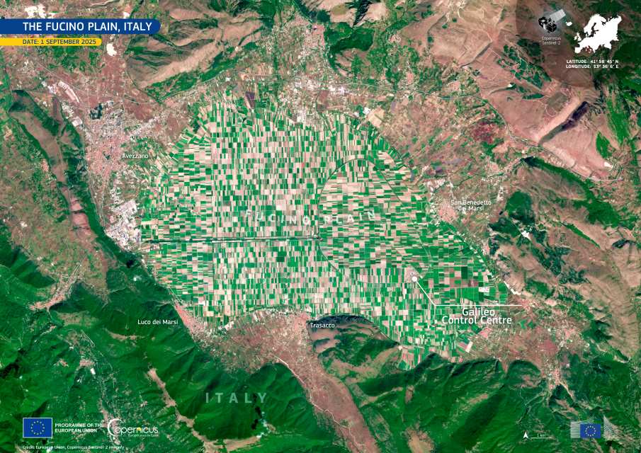
The Fucino Plain in central Italy appears as a striking patchwork of rectangular fields in this image captured by one of the Copernicus Sentinel-2 satellites on 1 September 2025. The region is one of the most intensively cultivated areas in the country, shaped by a remarkable transformation from water to farmland.
Once occupied by Lake Fucino, this large depression was the third largest lake in Italy until it was drained in the 19th century. Efforts to remove the lake had been attempted as far back as the 1st century AD under Emperor Claudius, who employed tens of thousands of workers to excavate canals and tunnels. When maintenance ceased after the fall of the Roman Empire, the waters reclaimed the basin. Centuries later, Alessandro Torlonia revived the project, completing a new drainage system between 1854 and 1875. The dried lakebed first became a swamp and then, through extensive reclamation, a fertile plain ready for cultivation.

Today, the Fucino Plain spans about 13,000 hectares of productive farmland. Its clayey-silt soils, rich in nutrients such as nitrogen, phosphorus and potassium, and its cool mountainous climate support a wide variety of crops. These include potatoes, carrots, spinach, chicory, tomatoes, fennel, endives, radishes, lettuce, cabbage and celery. The area’s distinctive conditions have given rise to the Fucino PGI carrot, known for its vivid orange color and high vitamin content.
The plain lies in Abruzzo and is surrounded by protected natural areas, including Sirente Velino Regional Nature Park, Abruzzo, Lazio and Molise National Park and Simbruini Mountains Regional Nature Park. In its western section stands the Galileo Control Centre, a key hub for the European Union Space Programme. From space, the Fucino Plain shows the precision of human cultivation etched into what was once open water.
Featured image credit: European Union, Copernicus Sentinel-2 imagery


