Sargassum is a type of floating brown algae that provides food, shelter, and habitat for many marine species in the open ocean, but when large rafts are carried toward the coast by winds and currents, they can become harmful to coastal environments. In recent years, large blooms have spread across the Atlantic basin, reaching beaches, bays, and nearshore waters from West Africa to the Caribbean and disrupting ecosystems while placing strain on tourism, fishing, and maritime operations. Forecasts and official warnings for 2026 point to another intense season, raising concern in areas that have faced repeated influxes.
Panama’s northern coastline combines ports, fishing communities, mangroves, coral habitats, and major shipping routes linking the Caribbean Sea to the Panama Canal. Colón, located along this corridor, is one of the country’s main maritime and urban centres. The surrounding area includes Limón Bay and nearby beaches and settlements that rely on stable marine conditions for transport, tourism, and local livelihoods. In March, notable accumulations of algae were observed in Playa La Langosta and along other sections of the Colón coastline, including La Escucha, Buenaventura, María Soto, Guanche, Cacique and La Guaira.
The presence of these algae is tied to a wider Atlantic system known as the Great Atlantic Sargassum Belt, which has expanded in the tropical ocean since the early 2010s. In open waters, sargassum provides habitat for fish, turtles, and other marine species. Once large quantities reach shallow zones and shorelines, however, environmental conditions change. Thick accumulations can limit sunlight penetration, reduce oxygen levels during decomposition, and place stress on seagrass beds and coral reef systems that depend on stable water quality.
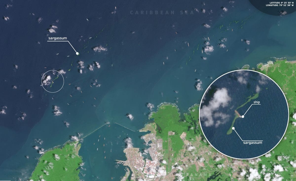
Satellite view of sargassum near Limón Bay

This image, acquired by one of the Copernicus Sentinel-2 satellites on 24 March 2026, shows sargassum floating near the entrance to Limón Bay, close to Colón. The contrast between the darker offshore waters of the Caribbean Sea and the lighter turquoise coastal zone highlights the algae, which appear as thin green streaks and curved filaments on the surface. Some patches are dispersed farther offshore, while others extend toward the coast and nearby shipping lanes. The annotated inset points to a distinct strip of sargassum close to a ship, helping distinguish the floating vegetation from clouds and variations in water colour.
The proximity of these accumulations to an area of dense marine traffic adds another layer of concern. Ships are visible in and around the bay, reflecting the strategic role of this coastline in regional trade and navigation. Large influxes of sargassum affect not only beaches but also small-scale fishing, navigation in coastal waters, and operations where ports and local services depend on clear access.
For nearby communities, the consequences extend beyond what is visible at the surface. Decomposition of the algae can lower oxygen levels in the water and contribute to conditions that harm sensitive marine habitats. Decaying masses may also produce unpleasant odours and release gases such as hydrogen sulfide, which can cause irritation for people in affected areas. Where accumulations persist, authorities face decisions on removal, disposal, and access to impacted shorelines.
The economic implications are also significant. Across the Caribbean, years with heavy sargassum influxes have led to rising clean-up costs and concerns for visitor-dependent economies. Fishing activity can be affected when nearshore waters become obstructed or when habitat quality declines. In Panama, where the Caribbean coast combines ecological value with maritime infrastructure and local tourism, the presence of these blooms near Colón shows that the issue is not limited to the more frequently affected areas farther north.
Satellite observation plays a central role in tracking these developments. Copernicus Sentinel-2 imagery allows detection of surface accumulations in coastal waters, while Copernicus Marine Service data provides additional insight into ocean conditions and the movement of floating material. Together, these tools support monitoring efforts, helping authorities identify exposed areas and plan responses as the 2026 season unfolds across the Caribbean.
Featured image credit: European Union, Copernicus Sentinel-2 imagery