Hurricane Melissa, which developed over the central Caribbean Sea on 22 October 2025, tore across the region with unprecedented force. It made landfall in Jamaica as a Category 5 hurricane – the most powerful ever recorded on the island – before continuing across the Jamaica Channel and hitting eastern Cuba as a Category 3 system. The storm left a trail of destruction, severely affecting lives, homes, and infrastructure across several Caribbean nations.
The disturbance that became Melissa had been monitored since around 16 October 2025 as it moved westward across the tropical Atlantic. By 21 October, it had strengthened into a tropical storm and was named Melissa, before rapidly intensifying into a major hurricane. On 25 October at 20:00, forecasts warned that Tropical Storm Melissa would strike Jamaica and the southern peninsula of Haiti, bringing heavy rainfall, destructive winds, flooding, and landslides. Hurricane conditions were expected over Jamaica during the weekend of 25 October and later across southern Haiti and Cuba.

Melissa posed a very high risk to Jamaica’s south coast, southern Haiti, and eastern Cuba. Its slow movement and severe rainfall, combined with storm surge, destructive winds, and landslide risks, created a potentially catastrophic event. More than 25 million people in Jamaica, Haiti, and Cuba were reported to be in the hurricane’s path. At least three deaths occurred in Jamaica and three in Haiti. Rapid mapping of flooding, blocked roads, and damaged buildings was deemed essential for disaster response.
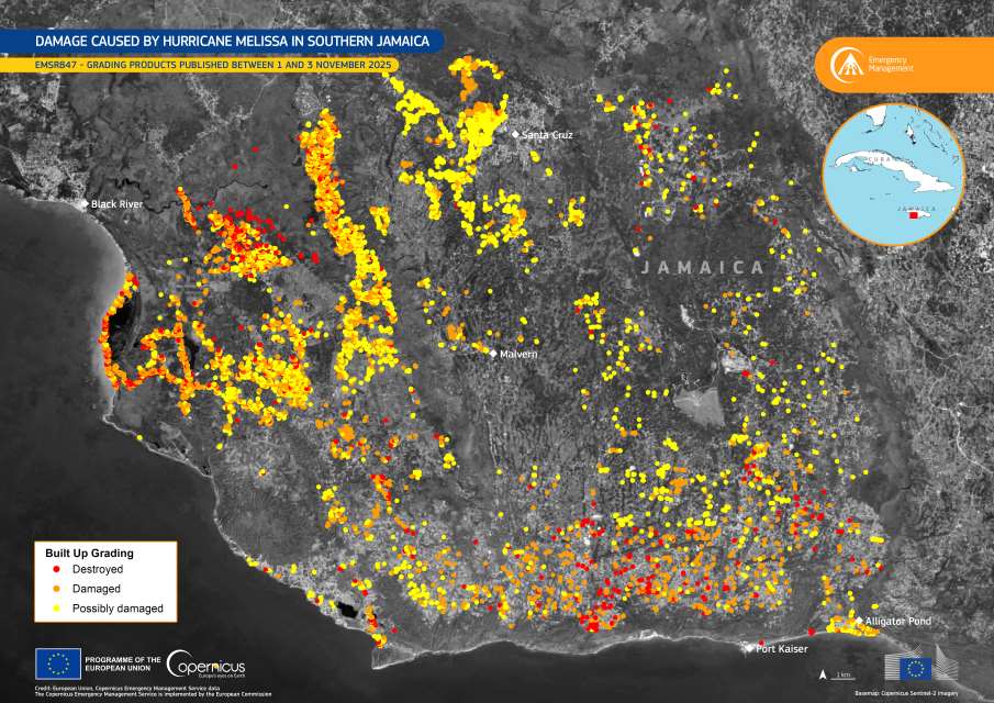
As the storm unfolded, the Copernicus Emergency Management Service (CEMS) was activated (EMSR847) to map flood extent and assess the damage in the hardest-hit areas. Covering 29 Areas of Interest, the activation has so far produced more than 31 mapping products, with further analyses underway. Based on over 30 satellite images, CEMS On-Demand Rapid Mapping estimated that approximately 8,910 individuals, 4,233 buildings (covering 34.4 hectares of built-up areas), and 113 kilometres of roads were potentially affected.
This visualisation presents the most recent grading maps for Jamaica’s Big Woods, Bull Savanna, Arlington, Santa Cruz, and Top Hill regions, illustrating the extent of flooding and infrastructure damage caused by Hurricane Melissa. The maps are part of the ongoing efforts by CEMS to support local and international emergency response operations with satellite-based data.
The image release coincides with the EU Science for Preparedness Conference, held from 4 to 6 November 2025. Organised by the Joint Research Centre – which implements CEMS – and the Disaster Risk Management Knowledge Centre, the event brings together scientists, policymakers, and practitioners to advance science-based crisis preparedness and response.
Featured image credit: European Union, Copernicus Emergency Management Service


