Argentina is one of the world’s major agricultural producers and exporters, supplying large volumes of soybeans, corn and processed soy products to global markets. In recent marketing years it has been the largest exporter of soybean meal and soybean oil, and also ranks among the leading exporters of corn. Because of this role in global agricultural trade, weather conditions across Argentina’s main farming regions are closely watched by farmers, commodity markets and policymakers worldwide.
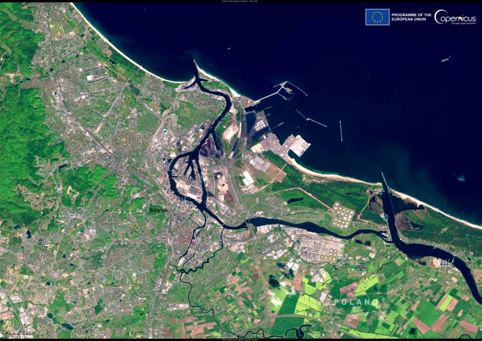
Much of this production comes from the fertile Pampas – a vast agricultural region covering parts of Santa Fe, Córdoba and Buenos Aires provinces. Within this landscape, the area around the city of Rosario plays a particularly important role. Located along the Paraná River in Santa Fe province, Rosario sits at the centre of Argentina’s grain-export corridor. The cluster of river ports around the city handles around 70–80 percent of the country’s grain and oilseed exports, making it one of the most important agricultural shipping hubs in the world. Crops harvested across the Pampas are transported to these terminals, where they are processed and loaded onto vessels bound for international markets.
In the 2025–2026 growing season, farmers across Argentina’s central agricultural belt faced unusually hot and dry conditions. In the core Pampas farming region near Rosario, January rainfall totalled about 38 mm, far below the typical monthly average of around 100–120 mm. The sharp rainfall deficit, combined with high temperatures, left crops under stress during crucial growth stages. Analysts warned that in some areas soybean and corn yields could decline by up to 50 percent as fields struggled with the lack of moisture.
Planting had already progressed across most of Argentina’s main agricultural areas. Farmers were expected to plant around 17–18 million hectares of soybeans and about 7–8 million hectares of corn during the 2025–2026 growing season, according to estimates from agricultural exchanges monitoring the campaign. However, the lack of consistent rainfall and the persistence of high temperatures created uncertainty about final yields as crops entered key development stages.

The images, acquired on 11 March 2025 and 1 March 2026 by the Copernicus Sentinel-2 mission, show agricultural land around Rosario in Argentina’s Santa Fe province. In the comparison, the 2025 image (on the left) and the 2026 image (on the right) reveal visible differences across the croplands surrounding the city. Fields that appeared greener in the earlier image show patchier and less vigorous vegetation in the more recent scene, reflecting the effects of dry conditions during the current growing season.
Climate drivers behind the drought
Weather patterns affecting southern South America often influence rainfall across Argentina’s agricultural heartland. One of the most important factors is the La Niña climate phase, which tends to bring warmer and drier conditions to parts of the Pampas during the summer months.
During the 2025–2026 season, meteorological and agricultural reports pointed to a combination of persistent heat and limited rainfall across central Argentina. A heatwave reported in late January added pressure on crops already affected by dry soils, particularly in the country’s core farming region where soybeans and corn dominate the landscape.
Dry periods linked to these climate patterns have affected Argentina repeatedly in recent years. When rainfall fails during key stages of the growing season, the effects can be seen not only in crop statistics but also in satellite imagery, where stressed vegetation often appears less vigorous and more uneven across large agricultural areas.
Monitoring agriculture from space
Satellite observations have become an important tool for monitoring environmental conditions and agricultural activity around the world. The European Union’s Copernicus programme, which operates the Sentinel satellite missions, provides frequent and high-resolution imagery that allows scientists and analysts to track vegetation health, drought conditions and seasonal changes across large regions.
By comparing images captured at different times, researchers can identify changes in crop growth and detect signs of environmental stress. Observations such as the Sentinel-2 views of farmland near Rosario help illustrate how weather patterns influence agricultural landscapes and provide data that support drought monitoring, agricultural assessments and climate research across some of the world’s key food-producing regions.
Featured image credit: European Union, Copernicus Sentinel-2 imagery