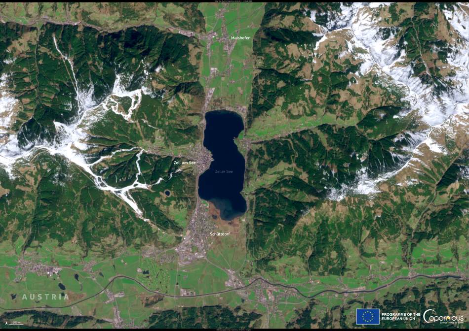
Surrounded by snow-dusted peaks and nestled in the heart of the Austrian Alps, Zeller See emerges as a striking feature in this Copernicus Sentinel-2 satellite image captured on 12 April 2025. The lake’s deep-blue hue, still prominent in early spring, sits in sharp contrast to the surrounding green lowlands and white mountain ridges — hinting at the changing seasons in this alpine region.
Zeller See lies just east of the Hohe Tauern National Park, one of the largest protected areas in Central Europe. Spanning over 1,800 square kilometers, the park is home to glaciers, high-altitude pastures, and iconic peaks such as the Grossglockner. The area is renowned for its rich biodiversity and strict conservation efforts. Hohe Tauern National Park plays a vital role in preserving alpine ecosystems and offers crucial habitat for golden eagles, marmots, and ibex, as well as a refuge for rare plant species adapted to high elevations.
Zeller See itself is modest in size — approximately 3.8 kilometers long and 1.5 kilometers wide — but reaches depths of up to 68 meters. According to tourism resources, the lake remains mostly ice-free even during the coldest winter months, thanks to the inflow of around 100 underground springs. This unique characteristic has made it a year-round attraction for visitors, supporting winter walks along the shoreline as well as summer sailing, paddleboarding, and swimming. The towns of Zell am See and Schüttdorf lie along the lake’s western and southern edges, respectively, benefiting from the lake’s ecological health and scenic beauty.

As climate change continues to affect alpine hydrology, monitoring lakes like Zeller See becomes increasingly important. High-resolution satellite imagery from the Copernicus Sentinel-2 mission enables detailed observations of seasonal changes, water levels, and land cover. Such data help scientists, planners, and conservationists balance the competing demands of tourism, water resource management, and environmental protection.
This image, with its clarity and rich coloration, offers more than just aesthetic value — it provides insight into how spring is unfolding across a region where snowmelt drives rivers and supports downstream agriculture. The meltwater from nearby glaciers and snowpacks not only feeds the lake but also influences the broader hydrological system of the Salzach River basin.
Satellite-based monitoring helps identify trends such as earlier snowmelt, shifting vegetation zones, and changing lake temperatures, developments that carry both ecological and economic implications. For areas dependent on seasonal tourism, understanding these changes supports better planning and adaptation strategies in the face of warming temperatures and changing precipitation patterns.
Zeller See stands as both a recreational haven and an environmental indicator. As part of the broader alpine landscape, its health reflects the state of surrounding ecosystems. Thanks to missions like Copernicus Sentinel-2, we can continue to observe and understand these dynamic relationships from above.
Featured image credit: European Union, Copernicus Sentinel-2 imagery


