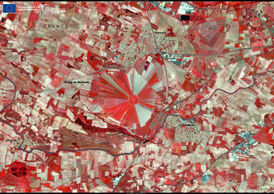
The Étang de Montady in southern France, near the town of Montady, offers one of the most striking examples of medieval land engineering still visible in the landscape. Once a vast wetland, it was drained in the 13th century through a sophisticated system of radial ditches that directed water toward a central collection point. This transformation not only turned the area into productive farmland but also left behind a distinctive sunburst pattern that remains a defining feature of the region.
The Copernicus Sentinel-2 satellite captured this false-colour image on 11 May 2024, revealing the geometric design of the landscape. The fields radiate outward like spokes of a wheel, intersected by canals and roads that continue to follow the medieval layout. While originally built for drainage and agriculture, the pattern has become both a cultural landmark and a visual reminder of how communities in the Middle Ages reshaped their environment to survive and thrive.

Today, the former wetland forms part of the broader heritage landscape of the Canal du Midi region. While the Canal du Midi itself is a UNESCO World Heritage Site, the Étang de Montady stands nearby as a striking example of medieval hydraulic engineering. The area illustrates the long history of human intervention in managing land and water resources in southern France.
Modern satellite data adds another dimension to this story, offering tools to monitor land use change, seasonal vegetation, and agricultural productivity. Open access to Sentinel imagery supports sustainable farming practices and water management, ensuring that landscapes shaped centuries ago can continue to provide for local communities while being studied from space.
Featured image credit: European Union, Copernicus Sentinel-2 imagery


