Explore the latest insights from top science journals in the Muser Press roundup (November 9, 2025), featuring impactful research on climate change challenges.
In brief:
Geography: Ways to achieve more accurate carbon budgets
How strongly do deforestation, reforestation, and agricultural expansion influence the carbon cycle? A team led by LMU researchers investigated why CO₂ fluxes from land use are still so uncertain and what can be done to better understand them. The findings are published in the journal Nature Reviews Earth & Environment.
CO₂ fluxes from land use: One of the largest uncertainties in the carbon cycle
Understanding how human land use affects carbon stocks in ecosystems is crucial for accurate climate projections and effective climate change mitigation strategies.
While deforestation releases CO₂, reforestation and sustainable forest management can increase the storage of carbon in vegetation and soil. However, the magnitude of these effects remains one of the key uncertainties in the global carbon cycle.
The new publication, led by LMU geographers Dr. Wolfgang Obermeier and Dr. Clemens Schwingshackl with the participation of Raphael Ganzenmüller and Professor Julia Pongratz as well as other researchers, sheds light on why different studies on CO₂ fluxes from land use sometimes differ greatly from one another and what methodological steps are necessary to harmonize the estimates in the future.
Comparison of key approaches
The team examined the most used methods for quantifying CO₂ fluxes from land use and land-use change. The result: differences in definitions, data sources, and model assumptions lead to substantial discrepancies and uncertainties.
The researchers show that none of the existing methods fully reflects all relevant processes. On this basis, they formulate proposals on how measurements, models, and reporting can be linked more consistently in the future.
Ways to achieve more accurate carbon budgets
To increase accuracy, the authors recommend, among other things:
- Closer collaboration between Earth-observation scientists, modellers and producers of national greenhouse gas inventories;
- More transparent communication of methodologies;
- Better integration of remote sensing, inventory, and modelling data.
These steps can help reduce uncertainties and improve carbon accounting worldwide as a basis for effective climate policy.
Significance for research and policy
The study clearly shows that technical measurement errors account for only part of the uncertainties. Systematic differences in definitions, data sets, and reporting systems are at least as important. The findings from the publication thus create an important basis better understanding the importance of land use for the global climate, making international reporting more transparent, and efficiently implementing ecosystem-based CO₂ removal from the atmosphere.
Journal Reference:
Obermeier, W.A., Schwingshackl, C., Ganzenmüller, R. et al., ‘Differences and uncertainties in land-use CO₂ flux estimates’, Nature Reviews Earth & Environment 6, 747–766 (2025). DOI: 10.1038/s43017-025-00730-6
Article Source:
Press Release/Material by Ludwig-Maximilians-Universität München (LMU)
Antarctic ice melt triggers further melting: Evidence for cascading feedbacks 9,000 years ago
A recent study published in Nature Geoscience has revealed that the substantial retreat of the East Antarctic Ice Sheet (EAIS) approximately 9,000 years ago was driven by a self-reinforcing feedback loop between ice melt and ocean circulation.
The research team, led by Professor Yusuke Suganuma from the National Institute of Polar Research (NiPR) and the Graduate University for Advanced Studies (SOKENDAI), found that the inflow of warm deep water into coastal East Antarctica caused the collapse of ice shelves, which in turn accelerated inland ice loss. The discovery indicates that Antarctic ice retreat is not merely a regional phenomenon; rather, it has the potential to propagate across multiple sectors through oceanic connections, thereby amplifying the overall magnitude of ice loss.
The phenomenon, in which meltwater from one region accelerates melting processes in other regions, is referred to as a “cascading positive feedback.” This feedback loop may be a crucial factor in comprehending the instability of Antarctic ice sheets, both in the past and in the present.
Uncovering the mechanism of past ice-sheet collapse
The present study aims to elucidate the mechanism of past ice-sheet collapse.
The East Antarctic Ice Sheet, which contains more than half of the world’s freshwater, is currently undergoing mass loss in certain coastal regions. It is imperative to comprehend the manner in which substantial ice sheets have responded to prior periods of climate warming, as this furnishes indispensable insights into their prospective stability in the context of the present global warming phenomenon.
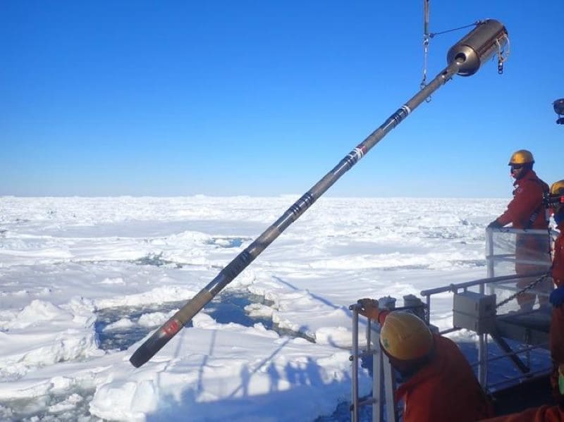
In order to investigate this phenomenon, the research team analysed marine sediment cores collected from Lützow-Holm Bay, which is located along the Sôya Coast in the vicinity of Japan’s Syowa Station. These cores were analysed in conjunction with geomorphological and geological surveys conducted across Dronning Maud Land. These sediments were obtained through multiple Japanese Antarctic Research Expeditions (JARE) between 1980 and 2023, including recent sampling from the icebreaker Shirase.
Utilising a range of analytical techniques, including sedimentological, micropaleontological, and geochemical analyses, the researchers were able to reconstruct past environmental changes in the bay and its environs. This reconstruction was facilitated by the use of measurements of beryllium isotope ratios (10Be/9Be). The results of the study indicated that approximately 9,000 years ago, the presence of warm Circumpolar Deep Water (CDW) intensified within the bay, resulting in the collapse of floating ice shelves. As the shelves disintegrated, they lost their buttressing effect, causing inland ice to flow more rapidly towards the ocean.
Modeling reveals a self-reinforcing feedback
In order to comprehend the factors that precipitated the augmented influx of warm deep water, the research team conducted climate and high-resolution ocean model simulations. The models demonstrated that meltwater discharged from other Antarctic regions, including the Ross Ice Shelf, disseminated throughout the Southern Ocean. This process resulted in the freshening of the surface layer and the intensification of vertical stratification. This phenomenon has been shown to suppress the upward mixing of cold surface water, thereby facilitating the intrusion of warm deep water towards the continental shelf of East Antarctica.
This process resulted in the establishment of a positive feedback loop, whereby meltwater led to stronger stratification, which in turn led to enhanced deep-water inflow, thereby further facilitating ice melt. The existence of such a cascading mechanism suggests that melting in one Antarctic sector may trigger or accelerate melting in others through oceanic teleconnections.

A warning from the past
The present study provides one of the clearest pieces of evidence to date that the Antarctic Ice Sheet may be susceptible to self-reinforcing, widespread melting in response to natural climate warming. Despite the occurrence of the event during the early Holocene epoch, a period characterised by elevated global temperatures relative to the last glacial period, the physical mechanisms elucidated by this study bear a direct relevance to the contemporary global warming phenomenon.
Current observations indicate that parts of the West Antarctic Ice Sheet, such as the Thwaites and Pine Island glaciers, are already undergoing rapid retreat driven by warm deep-water intrusion. In the event of analogous cascading feedbacks being in operation in the present day, there is the possibility of regional melting spreading and accelerating the overall ice-sheet loss, thus contributing to accelerated global sea-level rise.
International collaboration and significance
The research involved collaboration among more than 30 institutions, including the National Institute of Polar Research (NIPR), the Geological Survey of Japan (AIST), the Japan Agency for Marine–Earth Science and Technology (JAMSTEC), the University of Tokyo, Kochi University, Hokkaido University, and international partners from New Zealand, Spain, and others. This interdisciplinary endeavour entailed the integration of geological field surveys, marine sediment analyses, cosmogenic nuclide exposure dating, and coupled climate–ocean modelling to achieve a comprehensive reconstruction of the ice-sheet–ocean system in East Antarctica.
Professor Suganuma concludes: This study provides essential data and modelling evidence that will facilitate more accurate predictions of future Antarctic ice-sheet behaviour. The cascading feedbacks identified in this study serve to underscore the notion that minor regional alterations can potentially engender global ramifications.
Journal Reference:
Suganuma, Y., Itaki, T., Haneda, Y. et al., ‘Antarctic ice-shelf collapse in Holocene driven by meltwater release feedbacks’, Nature Geoscience (2025). DOI: 10.1038/s41561-025-01829-7
Article Source:
Press Release/Material by Research Organization of Information and Systems (ROIS)
In the US, Western rivers may be allies in the fight against climate change
For decades, scientists have generally thought that rivers emit more carbon dioxide, a greenhouse gas, than they take in. But a new analysis of every river network in the contiguous United States – including underrepresented rivers in deserts and shrublands – challenges this assumption, uncovering hints that many Western waterways may be soaking up carbon dioxide from the atmosphere.
The findings were published in Science and led by Taylor Maavara, an aquatic biogeochemist at Cary Institute of Ecosystem Studies.
“Rivers are one of the most uncertain parts of the global carbon cycle,” explained Maavara. “So in terms of balancing the global carbon budgets, figuring out where the carbon in rivers is coming from and and where it’s going is essential.”
One of the biggest sources of uncertainty in rivers is metabolism – the balance between how much carbon dioxide rivers soak up through photosynthesis, and how much they emit through the respiration of plants, animals, and microbes. Historically, monitoring data on river metabolism has been biased toward forested rivers in temperate areas. Using machine learning, Maavara and colleagues upscaled large observational datasets for a more holistic view. The study is the largest analysis of river metabolism to date, including monthly and annual photosynthesis and respiration rates for all the streams and rivers in the US.
“Estimating stream metabolism at large scales has been an elusive problem despite its importance to understanding the food webs of these unique and biodiverse systems,” said co-author Pete Raymond of Yale University. “This work has advanced our understanding of how streams function, which will allow for better stewardship of these important ecosystems.”
The team used US Geological Survey data to establish photosynthesis and respiration rates at hundreds of sites across the country. Then they used those data to train a machine learning algorithm to rank the factors driving photosynthesis and respiration rates. Factors included light availability, water temperature, nutrient and organic matter, and river flow rates. The model was then able to estimate photosynthesis and respiration rates for river reaches where data hadn’t been collected.
Until now, scientific thinking about rivers’ role in the carbon cycle has been largely biased by studies in the Northeastern US, where rivers tend to flow through forests in temperate climates. In these environments, where there is less light to feed photosynthesis and lots of organic carbon washing into streams to feed respiration, rivers tend to emit more carbon dioxide than they absorb. Hence, scientists inferred that most rivers must be predominantly carbon emitters.
However, Maavara and team show that when models include understudied areas like deserts, arid environments, and shrub lands where there’s less canopy cover blocking sunlight, and less organic carbon washing into the stream, rivers can act as carbon sinks.
“That’s what we see happening out West, where there are more of these arid environments,” Maavara explained. Results indicate that about 25% of western river reaches take in more carbon than they emit on a yearly basis, compared to 11% of eastern reaches.
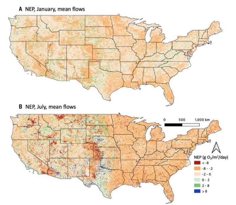
“Our work suggests rivers that were considered outliers in previous studies may be more common than we thought, especially in these understudied areas,” said Maavara.
Taken as a whole, rivers in the US still emit more carbon than they absorb, but the new numbers suggest the deficit may be much lower than previously thought. And Maavara suspects that these trends may apply more broadly at a global scale, since 65% of the world’s land cover is arid or semi-arid.
Intriguingly, climate change may be making rivers in the western US into better carbon sinks, at least for now. With hotter temperatures and lower precipitation, rivers are flowing more slowly, allowing sunlight to penetrate further into the water, allowing for more photosynthesis and hence more carbon absorption. However, if the rivers dry up entirely, this benefit goes away and the streams can instead become a source of carbon dioxide.
Maavara cautions that much uncertainty remains in calculating the carbon budgets of rivers and streams. However, “this study takes us several steps closer to narrowing the big gap in terms of understanding in the carbon cycle, which in turn will help us manage and mitigate the CO2 in the atmosphere.”
Journal Reference:
Taylor Maavara et al., ‘River metabolism in the contiguous United States: A West of extremes’, Science 390, 622-627 (2025). DOI: 10.1126/science.adu9843
Article Source:
Press Release/Material by Cary Institute of Ecosystem Studies
Hotter than your average spa bath: Extreme warming of Amazon lakes in 2023
An unprecedented heatwave and drought in 2023 turned the Amazon’s lakes into shallow simmering basins, with water temperatures soaring to temperatures above 40 degrees Celsius (ºC) in one case and water levels plunging to record lows, researchers report.
The extreme temperatures had impacts ranging from isolating remote riverine communities to driving mass die-offs in fish and endangered Amazon river dolphins. The findings confirm a worrisome warming trend across the Amazon’s poorly monitored lakes and rivers and portend escalating climate impacts on tropical freshwater ecosystems worldwide.
“Although this study presents data from 2023, in September and October of 2024, another extreme drought occurred in the central Amazon,” write Ayan Fleischmann and colleagues, “with new record-breaking low water levels and severe lake water heating associated with hydrological and meteorological conditions similar to those observed in 2023.” Aquatic ecosystems worldwide are warming rapidly. This increase is projected to continue under ongoing climate change, resulting in more frequent and severe lake heatwaves. Although lakes are considered sentinels of climate change, most research has focused on temperate regions. Tropical lakes, like those in the Amazon, are highly vulnerable to intense warming yet remain understudied and poorly monitored.
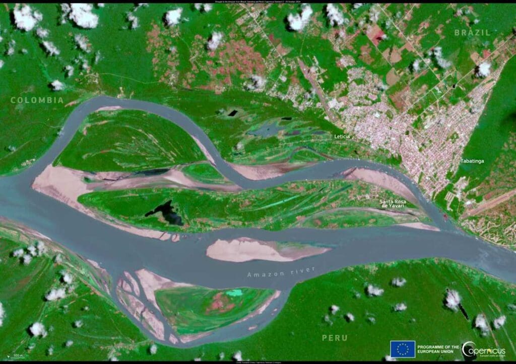
Here, Ayan Fleischmann and colleagues present an analysis of water temperature measurements from 10 central Amazonian lakes during the 2023 drought. Supported by satellite data and hydrodynamic modeling, Fleishmann et al. show how intense drought and heat combined to dramatically raise water temperatures. According to the findings, temperatures in 5 of the 10 lakes experienced exceptionally high daytime water temperatures, exceeding 37 ºC. Notably, temperatures in the shallow waters of Lake Tefé soared as high as 41 ºC – hotter than your average spa bath – throughout its 2-meter water column. According to the authors, a combination of extremely low water levels, strong solar heating, calm winds, and high turbidity created ideal conditions for severe lake heatwaves in the Amazon.
The findings suggest that low wind speeds were likely the most critical driver of extreme warming, more so than air temperature itself. With little wind, less heat was lost through evaporation and nighttime cooling, allowing lakes to grow progressively hotter under intense sunlight and persistent clear skies. What’s more, the authors show that Amazon lakes have been warming rapidly – roughly 0.3 to 0.8 ºC per decade over the last 30 or so years – rates higher than the global average. Many lakes in the region also shrank dramatically during the 2024 drought, with Lake Tefé losing 75% of its area and Badajós Lake shrinking by 90%.
Journal Reference:
Ayan Santos Fleischmann et al., ‘Extreme warming of Amazon waters in a changing climate’, Science 390, 606-611 (2025). DOI: 10.1126/science.adr4029
Article Source:
Press Release/Material by Walter Beckwith | American Association for the Advancement of Science (AAAS)
Featured image credit: Gerd Altmann | Pixabay


