Arctic sea ice extent has entered December at levels rarely seen for this time of year, continuing a pattern that developed through late autumn. Satellite observations show that the seasonal freeze has progressed more slowly than usual, leaving large areas of the Arctic Ocean with less ice than the long-term norm.
At the beginning of December 2025, data from EUMETSAT’s Ocean and Sea Ice Satellite Application Facility indicate that Arctic sea ice extent was the lowest ever observed for early December. On 17 December, the total extent was estimated at around 11.4 million square kilometres, remaining well below the 1991–2020 average despite the ongoing winter growth.
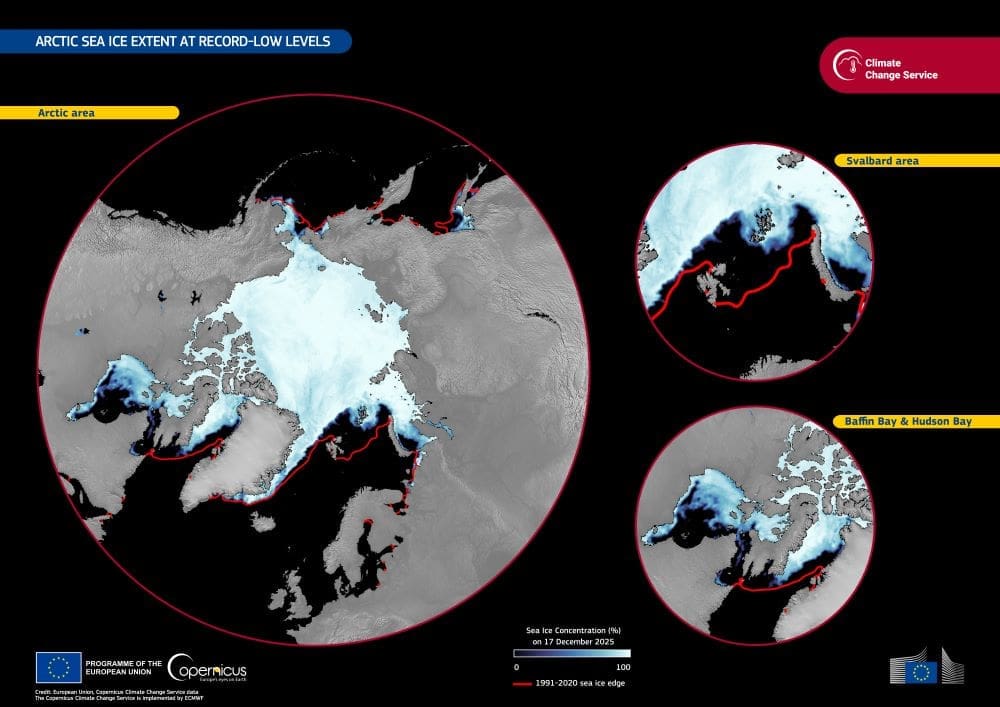
Based on Copernicus Climate Change Service data, the image shows how Arctic sea ice was distributed on 17 December 2025. The reference line for the 1991–2020 December average places the current extent well below typical conditions, with reduced ice cover evident near eastern Svalbard and across the north-eastern Canadian Arctic, including Baffin Bay and northern Hudson Bay.

These conditions follow an already unusual November. During that month, average Arctic sea ice extent was about 9.1 million km², roughly 1.2 million km² – around 12% – below the 1991–2020 average. This ranked as the second-lowest November extent in the 47-year satellite record, exceeded only by 2016. The shortfall was also notably larger than in recent years, when November values were typically 2% to 4% below average.
Although ice continued to form through November, the pace of growth lagged behind the long-term mean from the final week of October onward. Daily ice extent ranked second lowest for much of the month and fell to the lowest value on record for the date on 30 November, at about 9.74 million km².
Regional patterns reveal where the losses were most pronounced. Sea ice concentrations were well below average in the western Eurasian sector – including areas around Svalbard, Franz Josef Land, and the Kara Sea – and in the north-eastern Canadian sector, covering Baffin Bay and northern Hudson Bay. In both regions, surface air temperatures during November were far above average, exceeding typical values by more than 7 °C in some locations. Elsewhere in the Arctic, conditions were closer to average, apart from a small area of above-average ice cover in the Chukchi Sea.
Long-term satellite records are crucial for placing such events in context. Continuous monitoring by Copernicus and OSI SAF allows scientists to track trends, calculate anomalies, and assess how polar sea ice is responding to a warming climate. These datasets provide the foundation for understanding ongoing changes in the Arctic and their wider implications.
Featured image credit: European Union, Copernicus Climate Change Service


