Explore the latest insights from top science journals in the Muser Press daily roundup (August 28, 2025), featuring impactful research on climate change challenges.
In brief:
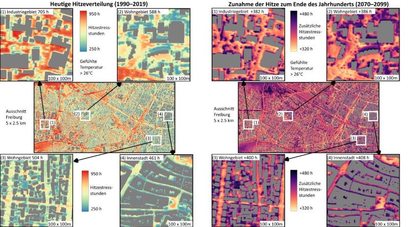
Deep-learning model visualizes urban heat stress at the meter scale
An interdisciplinary team of researchers from the University of Freiburg and KIT developed a deep learning model to calculate at high resolution and over long periods of time how heat stress in urban areas would develop per square meter in the future. The researchers used the city of Freiburg for a case study, published in Urban Climate.
The deep-learning system combines geodata such as building heights and vegetation structures with weather forecasts or climate projection data such as air temperature and radiation. The model is suitable for predicting different climate scenarios, from a climate where warming is reduced due to effective climate protection measures to a significantly warmer climate because of very high greenhouse gas emissions.

Increasing Heat Stress Expected for Freiburg
Using the deep learning model, the researchers simulated the future urban climate in Freiburg for 2070 to 2099 based on three scenarios. In the most pessimistic scenario, up to 307 hours per year with a strong heat stress of over 32 degrees Celsius “perceived” temperature during the day would be possible. In the reference period between 1990 and 2019, there were only 135 hours per year.
The number of hours with very strong heat stress of over 38 degrees Celsius “perceived” temperature might even increase by a factor of ten: 71 hours a year in the period between 2070 and 2099, compared to seven hours a year during the reference period. In comparison, the number of strong heat stress hours in the lowest-warming scenario only increases to 149 per year. In this scenario, the number of hours with very strong heat stress amounts to twelve.
The effects of heat stress within a city are diverse. “Factors such as the density of development, the vegetation, and the air circulation determine whether an area will remain comparably cool or whether the heat accumulates,” explains Dr. Ferdinand Briegel, lead author of the study and postdoctoral researcher at KIT’s Institute of Meteorology and Climate Research.
The aim of the study is to measure the heat stress affecting representative urban areas in Freiburg, i.e. an industrial zone, a residential area with old trees, and the historic city center with mid-rise buildings and little vegetation. The results show that the number of heat hours increases particularly in industrial zones because of its many paved surfaces and little shadowing.
“Densely developed areas with old trees cast shadows during the day so that the heat hours increase moderately. In the night, however, this building and tree structure slows down the cooling process so that the heat stays on,” says Briegel.
“With our deep leaning model, we can analyze heat development virtually in the neighborhood scale,” says Professor Andreas Christen, Chair of Environmental Meteorology at the University of Freiburg. “Since each city features its own development, greening, and geographical location, and thus has an individual structure, it is crucial to calculate the heat stress as granularly as possible. This is the only way to develop custom measures that can protect the inhabitants effectively from extreme heat.”
After validation and adaptation to specific conditions, the model can be customized and used for any other city.
In the next funding period of the Helmholtz Association, urban research will be a central topic for the first time. Cooperations such as this one between KIT and the University of Freiburg show how important networked research for significant future-related topics is.
Journal Reference:
Ferdinand Briegel, Simon Schrodi, Markus Sulzer, Thomas Brox, Joaquim G. Pinto, Andreas Christen,
‘Deep learning enables city-wide climate projections of street-level heat stress’, Urban Climate 62, 102564 (2025). DOI: 10.1016/j.uclim.2025.102564
Article Source:
Press Release/Material by Karlsruher Institut für Technologie (KIT)
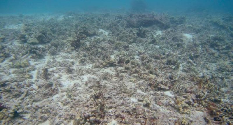
ASU study exposes sewage contamination locations threatening West Hawai’i coral reefs
The study identifies exactly where sewage-contaminated water is entering the ocean, further damaging coral reefs already impacted by climate change and endangering human health.
Researchers with the ASU Center for Global Discovery and Conservation Science used advanced airborne mapping techniques aboard the ASU Global Airborne Observatory, along with comprehensive field sampling and sophisticated statistical models, to pinpoint locations where high levels of fecal bacteria associated with populated coastal areas are driving worsening contamination.

The study, published in Frontiers in Marine Science, provides the critical data needed by government officials and local communities to mitigate this threat and protect the health and biodiversity of coastal ecosystems.
“Itʻs concerning how many sites we tested were contaminated, but not surprising when we consider statewide, 55 million gallons of wastewater effluent enters the ground each day – much of that within a few hundred yards of the coast,” said Kelly Hondula, the study’s first author and an associate research scientist with the ASU Center for Global Discovery and Conservation Science in the Julie Ann Wrigley Global Futures Laboratory.
“The results are clear. The high number of cesspools and faulty wastewater systems, and amount of land development along the coast, are highly predictive of whether the water is contaminated,” she said.
Much of the contaminated water entering the ocean comes from submarine groundwater discharge – basically, groundwater that flows directly into the ocean from the land instead of through rivers or streams. The water seeps through sediment and porous rocks along coastlines, bringing with it contaminants from tens of thousands of cesspools, leaking septic systems, and overbuilt coastal urban areas.

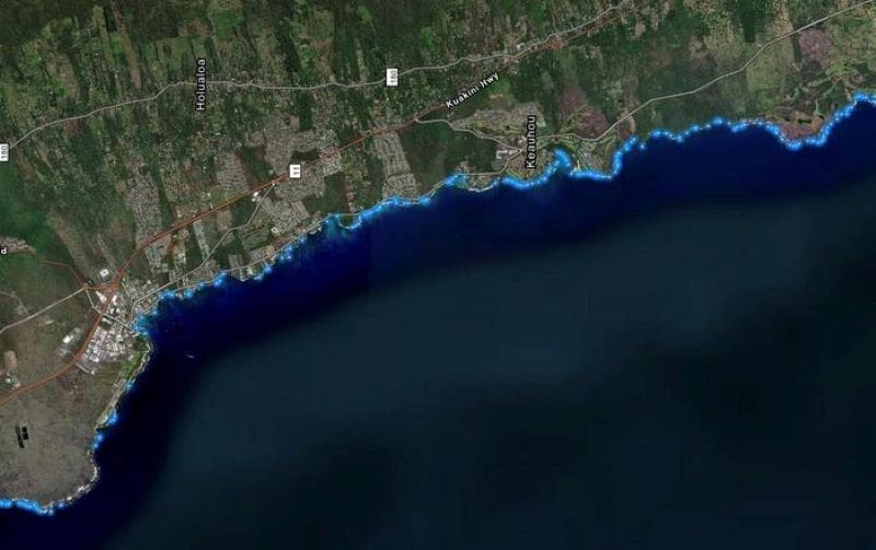
According to the State of Hawaii’s Department of Health, there are more than 88,000 cesspools in the state, with approximately 55,000 on the Big Island alone. Tens of thousands of cesspools and other leaking wastewater systems pose a risk to local water resources and coral ecosystems. More than 1,000 discharge sites along the West Hawaii coastline were mapped in 2024.
Fixing the problem requires converting outdated wastewater systems to more advanced wastewater treatment units. However, pinpointing specific locations to prioritize for mitigation has been a challenge for officials, especially in the context of submarine groundwater discharge that moves contaminants into the coral reef system.
Understanding more precisely where this discharge occurs and how contaminated it is is difficult to study. The research team collected water samples from 47 sites along 120 miles of the West Hawaiʻi coastline from finely mapped locations of submarine groundwater discharge. Then they used landscape-scale statistical models to identify areas susceptible to contamination through the coastal groundwater-connected system.
Key findings
In 42% of the 47 sampled sites, the team found elevated levels of Enterococcus, a key fecal indicator bacteria which identifies sewage contamination. Of these sites, 23% exceeded health risk thresholds, which means the water poses a direct threat to human health as well as to the environment.
The researchers also found two clearly linked factors causing the contamination: the presence of inland on-site sewage systems (mostly cesspools and septic systems) and the prevalence of high-density land cover near the coastline – particularly coastal urban development.

Additionally, the study confirms that submarine groundwater discharge acts as a major conduit that delivers sewage-contaminated groundwater directly onto some of West Hawai’i’s most vulnerable coral reefs.
Highlights from the study show that contaminated submarine groundwater discharge varies but is influenced by even small increases in infrastructure near the coastlines.
In the southern portion of the study area, a region called South Kona is especially vulnerable to water contamination because of increased coastal development and because it has a porous, volcanic land base that allows sewage to travel quickly through the underground natural water system.
The South Kona area is a critical environmental area for both coral and fish populations.
The good news
“This study provides crucial insight into the impacts of development on our coastal ecosystems that will help us prioritize upgrades to our wastewater infrastructure,” said County of Hawaiʻi Mayor Kimo Alameda. “We are grateful to the ASU research team for their commitment to this important work. Their findings will play an important role in helping us protect our coral reefs for future generations.”
The team’s landscape-scale statistical model can predict the likelihood of sewage and bacterial contamination for each submarine groundwater discharge site mapped along the West Hawai’i coastline. The model, which considers upstream land cover and known sewage sites, can help inform state policy- and decision-makers and guide restoration.
“The findings not only provide tactical information for government- and community-based interventions on land, they indicate where interventions are most needed as part of our reef restoration program here in Hawaiʻi. Restoration is not just about planting corals, it involves a spectrum of land management, reef interventions, and education effort,” said Greg Asner, senior author of the study, professor in the ASU School of Ocean Futures, and director of theʻĀkoʻakoʻa Reef Restoration Program.
The research team encourages a multi-faceted approach to mitigating sewage pollution, including continuing to replace cesspools and septic tanks with newer, more effective wastewater treatment systems, targeting restoration in the areas most likely to protect coral reefs and human health, and implementing new, advanced green infrastructure to reduce the impact of coastal development on groundwater quality.
Journal Reference:
Hondula KL, Martin RE and Asner GP, ‘Variability in contamination of submarine groundwater discharge into West Hawai‘i coral reefs’, Frontiers in Marine Science 12: 1634234 (2025). DOI: 10.3389/fmars.2025.1634234
Article Source:
Press Release/Material by Sandy Keaton Leander | Arizona State University (ASU)
Simpler models can outperform deep learning at climate prediction
Environmental scientists are increasingly using enormous artificial intelligence models to make predictions about changes in weather and climate, but a new study by MIT researchers shows that bigger models are not always better.
The team demonstrates that, in certain climate scenarios, much simpler, physics-based models can generate more accurate predictions than state-of-the-art deep-learning models.
Their analysis also reveals that a benchmarking technique commonly used to evaluate machine-learning techniques for climate predictions can be distorted by natural variations in the data, like fluctuations in weather patterns. This could lead someone to believe a deep-learning model makes more accurate predictions when that is not the case.
The researchers developed a more robust way of evaluating these techniques, which shows that, while simple models are more accurate when estimating regional surface temperatures, deep-learning approaches can be the best choice for estimating local rainfall.
They used these results to enhance a simulation tool known as a climate emulator, which can rapidly simulate the effect of human activities onto a future climate.

The researchers see their work as a “cautionary tale” about the risk of deploying large AI models for climate science. While deep-learning models have shown incredible success in domains such as natural language, climate science contains a proven set of physical laws and approximations, and the challenge becomes how to incorporate those into AI models.
“We are trying to develop models that are going to be useful and relevant for the kinds of things that decision-makers need going forward when making climate policy choices. While it might be attractive to use the latest, big-picture machine-learning model on a climate problem, what this study shows is that stepping back and really thinking about the problem fundamentals is important and useful,” says study senior author Noelle Selin, a professor in the MIT Institute for Data, Systems, and Society (IDSS) and the Department of Earth, Atmospheric and Planetary Sciences (EAPS).
Selin’s co-authors are lead author Björn Lütjens, a former EAPS postdoc who is now a research scientist at IBM Research; senior author Raffaele Ferrari, the Cecil and Ida Green Professor of Oceanography in EAPS and director of the MIT Program in Atmospheres, Oceans, and Climate; and Duncan Watson-Parris, assistant professor at the University of California at San Diego. Selin and Ferrari are also co-principal investigators of the Bringing Computation to the Climate Challenge project, out of which this research emerged.
The paper was published in the Journal of Advances in Modeling Earth Systems.
Comparing emulators
Because the Earth’s climate is so complex, running a state-of-the-art climate model to predict how pollution levels will impact environmental factors like temperature can take weeks on the world’s most powerful supercomputers.

Scientists often create climate emulators, simpler approximations of a state-of-the art climate model, which are faster and more accessible. A policymaker could use a climate emulator to see how alternative assumptions on greenhouse gas emissions would affect future temperatures, helping them develop regulations.
But an emulator isn’t very useful if it makes inaccurate predictions about the local impacts of climate change. While deep learning has become increasingly popular for emulation, few studies have explored whether these models perform better than tried-and-true approaches.
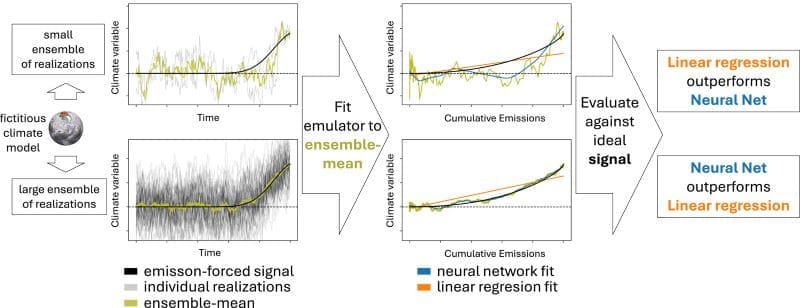
The MIT researchers performed such a study. They compared a traditional technique called linear pattern scaling (LPS) with a deep-learning model using a common benchmark dataset for evaluating climate emulators.
Their results showed that LPS outperformed deep-learning models on predicting nearly all parameters they tested, including temperature and precipitation.
“Large AI methods are very appealing to scientists, but they rarely solve a completely new problem, so implementing an existing solution first is necessary to find out whether the complex machine-learning approach actually improves upon it,” says Lütjens.
Some initial results seemed to fly in the face of the researchers’ domain knowledge. The powerful deep-learning model should have been more accurate when making predictions about precipitation, since those data don’t follow a linear pattern.
They found that the high amount of natural variability in climate model runs can cause the deep learning model to perform poorly on unpredictable long-term oscillations, like El Niño/La Niña. This skews the benchmarking scores in favor of LPS, which averages out those oscillations.
Constructing a new evaluation
From there, the researchers constructed a new evaluation with more data that address natural climate variability. With this new evaluation, the deep-learning model performed slightly better than LPS for local precipitation, but LPS was still more accurate for temperature predictions.
“It is important to use the modeling tool that is right for the problem, but in order to do that you also have to set up the problem the right way in the first place,” Selin says.
Based on these results, the researchers incorporated LPS into a climate emulation platform to predict local temperature changes in different emission scenarios.
“We are not advocating that LPS should always be the goal. It still has limitations. For instance, LPS doesn’t predict variability or extreme weather events,” Ferrari adds.
Rather, they hope their results emphasize the need to develop better benchmarking techniques, which could provide a fuller picture of which climate emulation technique is best suited for a particular situation.
“With an improved climate emulation benchmark, we could use more complex machine-learning methods to explore problems that are currently very hard to address, like the impacts of aerosols or estimations of extreme precipitation,” Lütjens says.
Ultimately, more accurate benchmarking techniques will help ensure policymakers are making decisions based on the best available information.
The researchers hope others build on their analysis, perhaps by studying additional improvements to climate emulation methods and benchmarks. Such research could explore impact-oriented metrics like drought indicators and wildfire risks, or new variables like regional wind speeds.
Journal Reference:
Lütjens, B., Ferrari, R., Watson-Parris, D., & Selin, N. E., ‘The impact of internal variability on benchmarking deep learning climate emulators’, Journal of Advances in Modeling Earth Systems 17, 8: e2024MS004619 (2025). DOI: 10.1029/2024MS004619
Article Source:
Press Release/Material by Adam Zewe | Massachusetts Institute of Technology (MIT)
Featured image credit: Gerd Altmann | Pixabay


