La Loire des confluences stretches along the middle Loire Valley in western France, from downstream of Tours to the south of Angers near Les Ponts-de-Cé. La Loire des confluences extends over 175 km of waterways and nearly 18,000 hectares, and the site includes municipalities such as Chinon and Montreuil-Bellay while marking the meeting point of several major tributaries of the Loire – the Cher, the Indre, the Vienne and the Thouet.
Over centuries the Loire and its tributaries have shaped the surrounding landscape, carving valleys and forming plateaus that support a wide range of natural environments. The river corridor contains sandy banks, secondary channels, floodplain meadows, backwaters and alluvial forests, creating a mosaic of habitats rarely found at this scale in western Europe.
Scientists have identified 34 notable habitat types in the area and recorded 218 plant and animal species protected at national or regional level. The wetlands also lie along an important migration route for birds, offering feeding and resting areas during seasonal journeys. Because of this ecological value, the site has received international recognition. La Loire des confluences meets all nine ecological criteria of the Ramsar Convention on Wetlands, a distinction achieved by only a small number of sites worldwide.
The area was officially designated a Ramsar wetland site on 26 February 2026, becoming the 57th Ramsar site in France. The Ramsar Convention is an international treaty adopted in 1971 that promotes the conservation and sustainable management of wetlands considered important at a global scale.

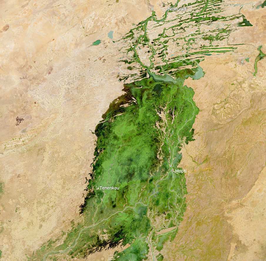
The image, acquired on 15 December 2025 by one of the Copernicus Sentinel-2 satellites, shows La Loire des confluences protected area between the cities of Angers and Tours in western France. The newly designated Ramsar site appears in yellow tones tracing the river corridor. The Loire follows a meandering course across the floodplain, while surrounding areas display winter vegetation in green shades and a patchwork of agricultural fields in brown, illustrating the mix of natural wetlands and cultivated landscapes that characterise the region.
Wetland habitats and threatened species
Characterised by diverse wetland environments including riverbeds, sandy beaches, floodplain meadows and mudflats, the area supports numerous threatened species. These include the internationally vulnerable starfruit (Damasonium alisma) and the asp viper (Vipera aspis). The allis shad (Alosa alosa) – listed as critically endangered in parts of its range – passes through the site during its migration.
The wetland regularly supports around 49,000 waterbirds, including species such as the black stork (Ciconia nigra). The area also hosts about 10% of the mainland French population of the osprey (Pandion haliaetus). In addition, the Loire floodplains provide habitat for a significant share of the global population of the light orange underwing moth (Archiearis notha), which reproduces in the region.
Beyond biodiversity, the wetlands provide a range of ecosystem services. These include nutrient cycling within the river system and the preservation of genetic resources that can contribute to the development of medicinal products. The territory also benefits from additional conservation measures through its designation as part of the European Union Natura 2000 network.
Satellite observations from the Copernicus programme play an important role in monitoring these landscapes. Data from the Sentinel satellites help scientists track changes in river channels, map wetland habitats and observe seasonal flooding across the Loire floodplain. These observations support long-term monitoring of the ecosystem and contribute to the management and protection of one of France’s most dynamic river wetlands.
Featured image credit: European Union, Copernicus Sentinel-2 imagery